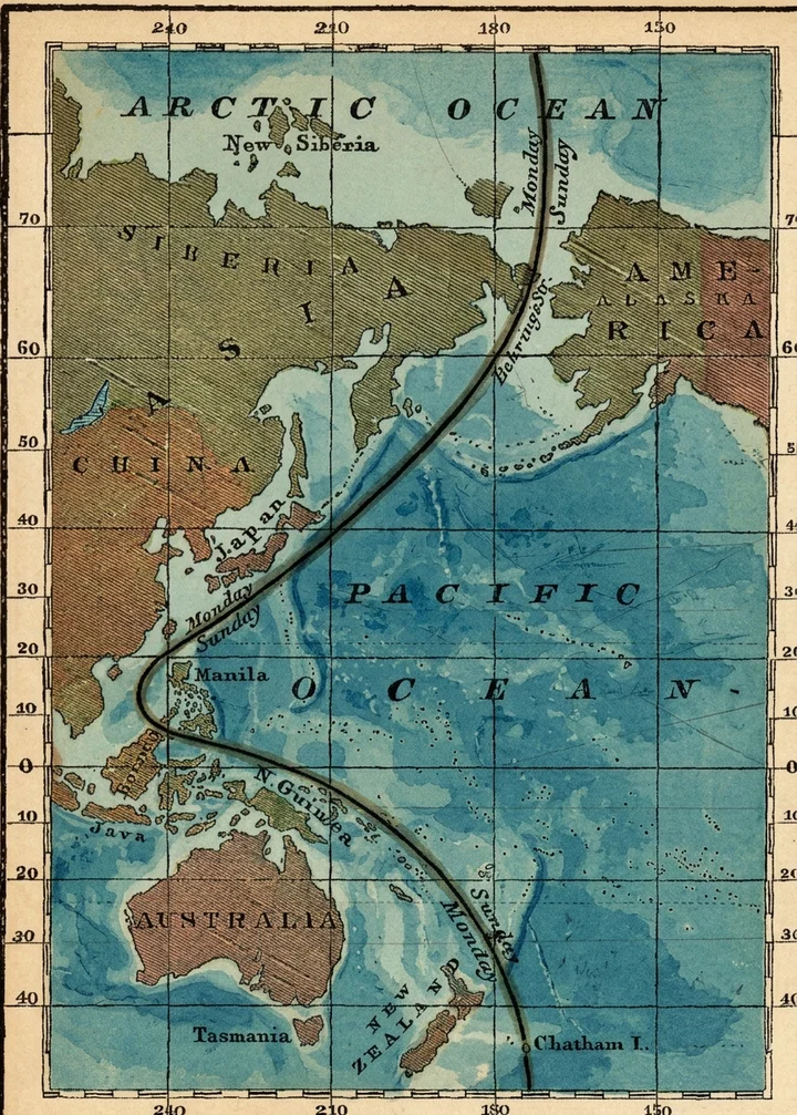
A CORRESPONDENT asks us where upon the surface of the earth the day-line is located, and what explanations can be given concerning it. Theoretically, the day-line is located on the 180th meridian from Greenwich; but practically it varies considerably from that meridian, as shown in the accompanying diagram, in which the heavy line running from north to south represents the day-line.
It passes through Behring’s Strait, and then takes a southwesterly direction to the Philippine Islands; thence, southeasterly, to Chatham Island and the south pole.
We say the line is practically located as here shown, because all those living directly east of this line are, in their reckoning, one day behind those living directly west of it. So in crossing the line from west to east, a day must be dropped; and in crossing it from east to west, a day must be added. A person crossing the line westward on Sunday noon, must change his count to Monday noon; and vice versa, a person crossing it eastward on Monday noon must drop his count back to Sunday noon.
The reason of this is apparent. When the earth was peopled the second time by the descendants of Noah, some traveling eastward carried with them the reckoning of time from their starting-point at Ararat to the eastern coast of Asia. Others, from the same point, carried the same reckoning of time westward to the western coast of Europe. In process of time, America was discovered, and the discoverers came from Europe, bringing their reckoning of time with them. From the same direction the American continent has been explored to its western extremities. Discoveries were also made westward in the Pacific Ocean. But meanwhile some islands east of Asia were peopled by inhabitants from that direction; and they established the dates they brought with them in the islands which they peopled. The two tides of migration practically came together on the line indicated in the diagram, and so dates have become established east and west of this line, as herein stated, without regard to their position relative to the 180th meridian. Thus Manila, the capital city of the Philippine Islands, is far west of Behring’s Strait; yet the day is one day behind the day at Behring’s Strait, because the Philippine Islands were peopled by persons from the American side, bringing with them their eastern dates. And the island of New Zealand, though far east of Manila, is one day in advance of the reckoning at Manila, because New Zealand was peopled from the Asiatic side, the people bringing their reckoning of time with them. And these dates having become established, it is now impracticable to change the arrangement, and place the day-line practically, as it is theoretically, on the meridian of longitude running directly north and south, through Behring’s Strait.
By this simple geographical fact, all confusion is avoided, and all difficulties arising from difference of dates are easily solved. The difference of reckoning in Alaska and Chatham Island is often referred to as an insuperable objection to the keeping of the Sabbath; but the question is evidently to be settled on this ground; namely, Alaska, lying east of the day-line, should conform in its reckoning to the American side, and those who now inhabit Chatham Island, coming from the same side, should adopt the same reckoning. The trouble in Alaska has arisen simply from the fact that those who crossed Behring’s Strait from Asia brought their Asiatic reckoning with them, instead of changing the day when they crossed the day-line, as they should have done.