(Continued.)
It is evident that there must be some fixed point, or line, where days have a beginning and ending, or where, if it may be so described, the ends of two days abut together, so that crossing that line, in either direction, we pass from one day into another. Locally, of course, the day has, everywhere upon the earth, a beginning and ending marked by the setting of the sun. But the idea now intended is, that there must be some place, not traveling around the globe like the sunset line, but permanently located upon the globe, and moving around with it, where days have a beginning and ending, or, to speak more accurately, where days are divided one from the other. That such a line would be established inevitably in the natural order of things, will be apparent if we follow in imagination the migrations of the human family, as in the course of ages they spread abroad east and west over the surface of the earth. When God said, “Let there be light,” one half of the globe was instantly lighted up, and the other half was immersed in shadow. That body of light evidently acted the same part which on the fourth day was assigned to our sun; for as the earth revolved through the light and shadow, there was evening and morning, or the light and dark part of the day, the same as now. There was therefore midnight, morning, noon, and sunset all at once; but day was counted as beginning at that point where the light, the equivalent of the sun, could have been seen as just sinking below the horizon. From that point there followed a period of twelve hours of darkness and twelve of light; and then one day was complete. “The evening and the morning were the first day.” And days have followed each other around the world in regular succession from that time to the present hour. When man was created, the day began with him, when “the sun did set” at the point where he was located; and as the human family multiplied and spread abroad upon the face of the earth, they would take the day with them as established at the point of departure, beginning it earlier or later, according as they journeyed east or west.
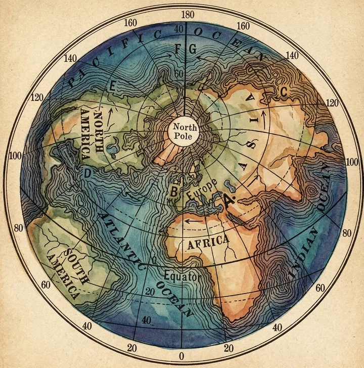
In the accompanying map, as the cradle of the human family is supposed to have been in the vicinity of the valley of the Euphrates, let “A” represent the spot. From that point they migrated, as numbers increased, east and west, as indicated by the arrows. Those going eastward finally reached the eastern coast of Asia at “C,” carrying with them the reckoning of the day as brought from “A,” beginning it earlier the farther east they went.
On the other hand, those who went westward reached, in time, the western coast of Europe and Africa at “B,” taking with them the same day as computed from “A,” only beginning it later and later the farther west they went.
For ages the broad Atlantic stayed the westward tide of civilization, at “B.” But at length the current of emigration broke the barrier, crossed the ocean, and reached the eastern coast of America at “D.” Crossing the continent, it carried the day on to the western coast at “E,” where it reached the Pacific. There they had the day as computed from “A,” only beginning it later and later the farther west they went.
That this so far is a correct view, is proved by the fact that a person may start eastward from “E,” and pass across America, the Atlantic Ocean, Europe, and Asia, around to “C,” computing his time all the way by the sun, and he will find that his reckoning agrees exactly with the time at all the places he passes in his journey. And so he may reverse his course, and, starting at “C,” go westward through Asia, Europe, across the Atlantic and America, back to “E,” and his count of days, going that way, will also agree with that of all the inhabitants along the entire route.
But now suppose two persons stationed at “C” and “E” to start toward each other by way of the Pacific Ocean, the one at “E” going westward toward “F,” and the one at “C” going eastward toward “G.” When they come together on the line between “F” and “G,” they find themselves twenty-four hours apart in their computation of time. But as there are but twenty-four hours in a day, they have now reached the point where some adjustment of the calendar must be made to conform to the operations of nature. In other words, they have reached the point where the days divide, and the time just west of the line is twenty-four hours earlier than that just east of it.
The conclusion, then, which we reach is this: The dividing line between days must come where the two tides of emigration starting out from “A,” the cradle of the race, one going eastward and the other westward, would come together in their progress around the world.
As a matter of fact, in the peopling of our earth, the two tides of emigration have come together in the Pacific Ocean, as represented on the map. For America was discovered from the east, and the time was brought from the Eastern Hemisphere westward to the Pacific, placing the line of division in the mid-Pacific, where the circuit of the earth was completed; or where persons from “C” and “E,” continuing their progress eastward and westward, would come together.
That this division line falls where it does, is altogether accidental, or perhaps better to say, circumstantial. It is all owing to the circumstance, or fact, that America was discovered from the east, and the reckoning of the day was brought from that direction, instead of being discovered from the west, bringing the day from that source. If some Chinese or Japanese Christopher Columbus had sailed eastward, from “C” to “E,” and this country had been peopled from that direction, bringing the time from “A” eastward, by way of “C” and “E,” to the Atlantic at “D,” then the two tides of emigration would have come together in the mid-Atlantic, and the day line, or dividing line between the days, would have been there instead of in the mid-Pacific.
It may perhaps be regarded as in a measure, at least, providential that circumstances have placed the line in the Pacific Ocean where a meridian may be drawn from the North pole to the South pole, without encountering any considerable body of land, and where the tide of travel is much less dense than it is across the Atlantic between Europe and America.
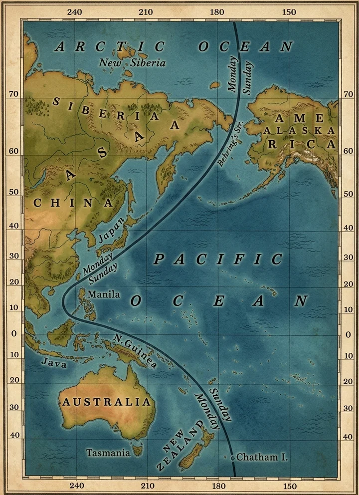
Having now found where the days divide, and why they divide there, we are prepared to understand why the day line, or, as it is called, the international date line, in actual practice, varies from this theoretical view of the subject, as we have it illustrated in the accompanying diagram.
Theoretically, the day line is a line running from the North pole to the South pole, through Behring’s Strait and the Pacific Ocean, near the 180th meridian of longitude east or west from Greenwich, England. But the first navigators westward across the Pacific, carried the time from the east far west of that meridian, even to the Philippine Islands, that group shown on the map, of which Manila is the capital. To other points in the Pacific, as Borneo, Australia, New Zealand, etc., the time was brought, not from the east by way of America, but from points west of them, by way of Asia and the Indian Ocean. And thus it came to pass that of various localities in the Pacific Ocean situated far east and west of each other, the eastern points have time one day in advance of the western. Thus at New Zealand, though situated many degrees east of the Philippine Islands and Manila, the time is one day in advance of what it is at the latter place. And these dates having become established, the date line has been run in accordance therewith. So running through Behring’s Strait, which is correct, the line bears away southwestward till it circles the Philippine Islands, to correspond to the dates of that locality, and then curves southeastward till it reaches a point a little east of the 180th meridian, but directly south of Behring’s Strait. Had time been brought to the Philippine Islands, and on to the mid-Pacific eastward by way of Asia, instead of westward by way of America, the line would have run straight north and south instead of curving as it does.
These facts also enable us to solve the problem of the difference of time as found in Alaska. The Alaskans coming from Asia across Behring’s Strait, brought the time of Asia over upon the American Continent, and were found reckoning their time one day in advance of that which had been broughtp. 617 from the east, and established upon all other portions of the continent. So in their matter of Sabbath-keeping they intended to keep the first day of the week, but took for that purpose, from their western reckoning, the day which has been established on this continent as the seventh. The day which they called Sunday, was here, east of the day line, Saturday. So they were literally doing what Seventh-day Adventists are falsely accused of doing; that is, “keeping Saturday for Sunday.” What ought they to have done? When they crossed Behring’s Strait, thus crossing the day line, they should have dropped the reckoning of their time back one day. As they did not, it remained to do it afterward. They needed not to change the day they were observing as the Sabbath; they had the right day; but they should change the reckoning of it, calling it the seventh, as it really is, not the first. The reason why their day should correspond to ours is apparent. For the American Continent, having received its day from the east and not from the west, except this small fraction of it, this should conform to the rest of the country, and let the dividing line run here as in all other localities, not through any portion of the country, but through the ocean between the two continents of America and Asia.
(To be continued.)