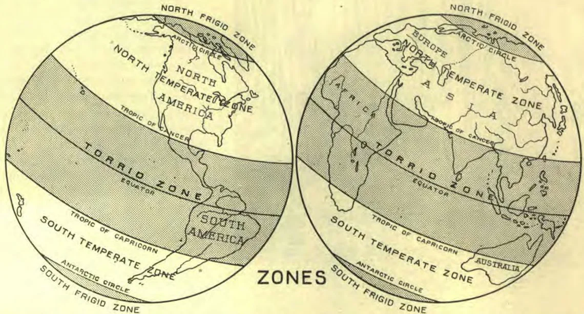
In making maps it is usually convenient to show only a small part of the world on one map. So it is necessary, in order for us to get an idea of what part of the world a map represents, to have some fixed rules for map-drawing. In drawing maps we always call the top north, the bottom south, the right side east, and the left side west.
But this is not all that is necessary. In order that one may know where he is on the earth, and in order to make it easy to draw maps, men have devised two systems of imaginary lines that divide the earth’s surface into small sections, or parts. Half-way between the poles we mark a line around the earth, dividing it into two equal parts. We call this line the Equator. As lines and circles are not of the same size, we can not measure them by miles or feet or inches; so we divide a circle into three hundred and sixty equal parts, called Degrees. Each degree is, in turn, divided into sixty equal parts, called Minutes; and the minutes are again divided into sixty equal parts, called Seconds.
ZONES
Twenty-three and one-half degrees north of the equator we mark another line, passing around the earth, from east to west, exactly parallel with the equator. We call this the Tropic of Cancer. Twenty-three and one-half degrees from the north pole is another line passing around the earth from east to west, parallel to the tropic of cancer. This line is called the Arctic Circle.
South of the equator, twenty-three and one-half degrees, is a line called the Tropic of Capricorn; and twenty-three and one-half degrees from the south pole we have another line, called the Antarctic Circle. Between these lines, we make as many others as we desire, running parallel to them.
These lines, all taken together, are known as Parallels, and mark the distance north or south of the equator. We call the distance north or south of the equator, Latitude, and it is marked on the sides of the map. Latitude is therefore in degrees.
The other system of lines runs around the earth from north to south, passing through both poles. These lines are called Meridians. We draw as many of these as we wish, then we choose one of them as the principal point to begin to reckon from, and call it the Principal Meridian. The distance eastward from that line is called East Longitude, and the distance west from it is called West Longitude.
Longitude is reckoned in degrees, and is marked at the top or bottom of the map. The greatest longitude that a place can have is one hundred and eighty degrees, or one half the distance around the world. The greatest latitude that a place can have is ninety degrees, or one fourth the distance around the world.
There are various meridians chosen from which to reckon longitude. In this country we usually reckon from the meridian of Washington, although sometimes we reckon from the meridian of Greenwich, England.
As we shall soon study the maps of the various continents of the world, it is necessary for us to know something about longitude and latitude. If you will look on the map of the world, you will find the meridian circles, and also some of the parallels.
REVIEW.—How do we tell the directions on a map? What is the equator? Name the tropics, and tell where they are. Where is the arctic circle? the antarctic? What is latitude? What are parallels? How do we reckon latitude? Where is it found on the map? What are meridian circles? What is longitude? What do we mean by the principal meridian? What is the greatest longitude a place can have? What is the greatest latitude a place can have?
NOTE TO TEACHERS.—In teaching this lesson, be sure that the pupil understands what a degree is, and why it is used; also be sure that he knows what the equator is, and knows the difference between longitude and latitude, and where to find each marked on the map. Show him, on the map, how a city is marked, and how we mark a capital city. Show him how rivers and mountain chains are designated. In fact, familiarize him with actual methods, explaining points that he does not understand, so he will have no trouble with the map questions that are to follow.
Lesson XV
“All the foundations of the earth are moved.” “Which removeth the mountains, and they know not: which overturneth them in his anger. Which shaketh the earth out of her place, and the pillars thereof tremble.”
One of the greatest effects of the flood is seen in the changing of the earth’s seasons, so that part of the year it is warm, and part cold.
When the earth was first created, its poles no doubt pointed north and south, and the sun shone on all parts of the earth every day. This made a warm climate over all the earth. In Greenland, where now it is very cold, we find remains of palms and other trees that grow only in a warm country. This shows that at one time it must have been warm there.
During the flood the foundations of the earth were moved, so now the poles do not point exactly north and south. They lack twenty-three and one-half degrees of doing so. This makes it so that the sun does not shine at the north pole for six months at a time, and then it shines all the time for six months. It is the same way at the south pole, only the sun shines there while it is dark at the north pole, and it is dark there while it shines at the north pole.
God says that the daysprings have taken hold of the ends of the earth, that the wicked might be shaken out of it. When it is dark so long at the poles, it gets very cold. When the day comes, the light shines at such a slant that it thaws out only a little of the ice and snow that had formed in the winter. For this reason it is cold and frozen there all the time, so no one can live there.
Around each pole is a broad belt of this kind of country that is called the Frigid, or frozen, Zone. So we have the North Frigid Zone and the South Frigid Zone. On your maps the imaginary line, called the Arctic Circle, marks the border of the north frigid zone, and a line called the Antarctic Circle marks the south frigid zone.
Lying on each side of the equator is a broad belt of country, in some part of which the sun is directly overhead at noon every day, and the days and nights are each about twelve hours long. It is always very warm there; and where there is rain enough, the trees are green all the year. This zone is forty-seven degrees wide, and we call it the Torrid, or hot, Zone. The torrid zone is bordered on the north by the Tropic of Cancer, and on the south by the Tropic of Capricorn.
Between the torrid zone and the north frigid zone is a broad belt of land which is neither so hot as the torrid zone nor so cold as the frigid zone. This we call the North Temperate Zone. Between the torrid zone and the south frigid zone is a similar zone called the South Temperate Zone.
REVIEW.—How does the axis of the earth point? Why? What effect does this have on the earth? Into how many zones does it divide the earth? Why has God thus changed the earth?